Data acquisition and
system control are implemented through the pop-up windows associated with
location-specific rectangular shapes on the simulator GUI (Figure 1). The
pop-up windows close when the parent image is clicked on; pop-ups may also
be moved and re-sized. Pop-up rectangles denoted by "V" and "Q" give annual
statistics for volume and discharge, respectively. For example, the Lake
Nasser volume button gives the annual total volume in Lake Nasser in BCM.
The Khartoum discharge button gives the annual total flow rate at Khartoum
in BCM/yr.
River discharge as a function
of time is tracked at a discrete number of points within the river network.
Hydrographs can be viewed by clicking on the corresponding section of the
river on the Nile map. These hydrographs are dynamic and evolve as the
user modifies the simulator conditions. Currently, the discrete points
at which hydrographs can be observed are coded directly in the simulation.
In the future, the user will be able to click on any reach of any river
in the basin and view its corresponding hydrograph.
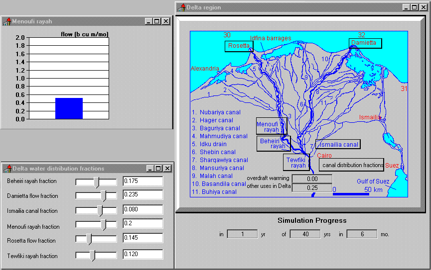
Along the course of the
lower Nile in Egypt, flows can be distributed among the major existing
canals and branches of the river. At the head of the Delta, the main Nile
River flow is divided among the Rosetta and Damietta branches of the river,
and among the four major delta canals taking water off from the river at
the barrages just north of Cairo. Default values for the fractions of flow
entering of these five distributaries (Said, 1993) are coded into the simulation
but may be altered by the user (Figure 2). In the example shown in Figure
2, one-fifth of the default 2.5 bcm/mo allocated for Deltaic use is distributed
to the Menoufi rayah.
Figure 2-Control of Flow
Distribution in the Nile Delta.

The geographic and hydrologic
features of the Nile River system were reduced to a flowchart schematic
for the purpose of model development (Figure 3). Inflows from the White
Nile and Blue Nile merge at Khartoum and are joined by the Atbara further
downstream. This is represented by a converging tree structure entering
upstream of Lake Nasser (Figure 3).
Figure 3-Nile River Network
Schematic.

Lake Nasser itself is
modeled with four effluents: downstream flow to Egypt, water withdrawals
by the Sudanese, losses to evaporation and seepage, and overflow released
into the Toshka depression. These inflows and outflows are summed at the
node representing Lake Nasser.
Incorporation of existing
flow containment structures, such as the Aswan high dam and the Roseires
dam, enables users to examine the effects of various flow release rates.
In addition to the modification of flow rates from existing structures,
the model also allows the construction of proposed flow control structures
within the time duration of a simulation. These future structures include
canals near the Sobat marshes, Jonglei, Bahr el-Ghazel, and the Toshka
depression, and dams at Lakes Edward and Victoria.
The simulator is based
on a detailed description of the physical hydrology of the river system
and is calibrated to empirical records of the basin. Its output reproduces
the descriptive statistics of observed hydrographs, reservoir levels, and
travel times of flood waves along river reaches. The NileSim model incorporates
monthly river flow variability from analyses described in the literature
(Said, 1993; Shahin, 1985). The monthly flow and volume estimates include
a stochastic component. The filling and draining of reservoirs obey mass
balance, and the travel times of flood waves downstream are described by
Manning's equation and geographically distributed reach geometries (McCuen,
1989).
One important feature
that distinguishes NileSim from earlier hydraulic simulation models is
its use of simulation technology drawn from other engineering disciplines
besides hydrology and civil engineering. This technology transfer is possible
because of the emergence within the past five years of computer-aided software
development tools for electrical engineering, mechanical design, and other
large market sectors. These software tools allowed NileSim to be built
in a functionally acceptable and cost-effective way. This produced a simulator
of the Nile that: (i) is easy to use; (ii) allows an intuitive visual interaction
between the user and the simulation; (iii) is physically realistic; and
(iv) was quick and inexpensive to develop.
The underlying network
simulation of the river basin was developed using VisSim (Visual Solutions,
Inc., 1995), a network simulation toolkit from the electrical engineering
industry. VisSim combines a graphical development environment for rapidly
building network diagrams with a set of mathematical and logical tools
for describing analytical relationships within such networks.
The Vissim simulation
engine underlying NileSim uses circuit-like logic to construct an analytical
representation of the Nile river basin from a series of river reaches,
reservoirs, mathematical operators, and time series functions. Some indication
of the complexity of the Vissim engine is suggested by Figure 4. The Nile
module in Vissim is shown in partial, expanded form to illustrate the connection
of lakes, reservoirs, and reaches in the Equatorial Lakes region. The Semliki
River reach (i.e., model channel 03) is further expanded to show the representation
of the depth-discharge function for that reach (Leopold and Maddock, 1953).
Figure 4-Four Levels of
Nested Modules in the Vissim
The NileSim GUI was built
using Delphi3.0 (Borland, 1997). The final code constructed using these
tools was compiled into a C-based executable for users to download from
the Internet. This strategy of using CASE tools rather than writing original
code allowed NileSim to be developed within a few months and to have both
the functionality and look-and-feel of standard Windows software; this
consistency with industry standards is important in simplifying training
and encouraging use.
Experimenting with the Nile System
At any time during a simulation,
the user can readily modify the hydrologic network or water allocations,
encouraging real-time experimentation. These changes may be made in several
ways. Changing water distributions or withdrawals redirects water flows
in the network. Altering reservoir discharges changes storages. Setting
the fractional flow in any agricultural water distribution canal to zero
turns off that part of the network. Changing the fractional flow from zero
turns on or introduces a new part of the network. Thus, experiments with
new or planned additions to the river system can be made by using the controls
for distribution fractions to turn on or off new structures.
During the simulation,
the user may create a dam, increase a dam height (e.g., Owen Falls dam),
and specify release discharges from any reservoir in the system. The effect
of these changes is to raise the respective lake level upstream and reduce
the variability of all flows throughout the river system downstream. Other
structures, such as dams on the Blue Nile or consumptive uses for agricultural
development anywhere within the basin, can be similarly modified in the
simulation. Finally, the user may add or remove water-bearing canals.
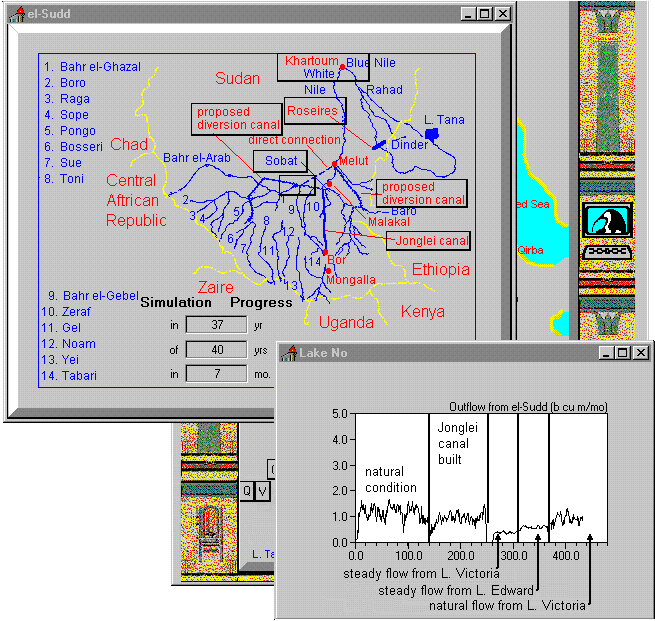
Three proposed canal projects
have been included in the simulation: the Jonglei canal, a diversion of
the Bahr el-Ghazel, and the Sobat marsh canal. In the default simulation
of the Nile River, these canals do not exist. The user may at any time
turn on one or more of these canals, and from that point in the simulation
forward (until turned off) the network is affected by the new diversions.
An example of experimentation
can be seen in Figure 5, where the outflow hydrograph from the Sudd into
Lake No is shown over a duration of 40 years. During the first 20 years,
changes to the basin are not made. At year 20, the Jonglei Canal is built
(i.e., turned on). Relatively quickly, the effect of the canal is seen
on the discharges from Lake No, even though the stochastic nature of the
flow from year to year makes this effect difficult to see one year at a
time. Subsequent effects of modification of flow from Lakes Victoria and
Edward change the average annual discharge and a reduction in variability.
Figure 5-Effects of Engineering
Modification on Outflow from el-Sudd.
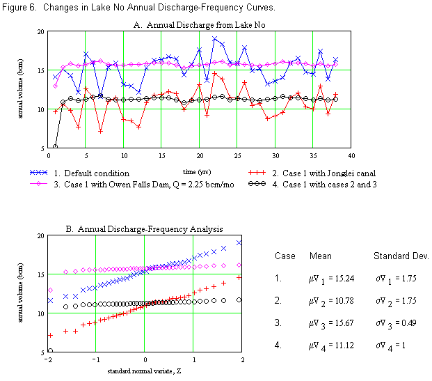
The annual discharge data
reported by NileSim (see Figure 6a) show the individual effects of the
construction of the Jonglei Canal and the regulation of outflow from Lake
Victoria at the Owen Falls Dam. Implementation of the Jonglei Canal reduced
the average annual discharge measured at Lake No from 15 bcm/yr (Case 1)
to 11 bcm/yr (Case 2). Construction of the Owen Falls Dam with a steady
release of 2.25 bcm/mo (Case 3) reduced the variability of the annual discharge
from 1.75 bcm/yr to 0.49 bcm/yr; this large drop in variability is largely
because the Victoria Nile is the principal source of water to the el-Sudd
region. Finally, the combination of the canal and the dam (i.e., Case 4)
reduces both the central tendency and variability of the annual discharge.
The effects of the engineering modifications on the characteristics of
the discharge-frequency curves (see Figure 6b) are clear from the respective
differences in central tendency and variation.
Figure 6. Changes in Lake No Annual Discharge-Frequence
Curves
Another interesting experiment
that can be performed is to test the effect of diverting water from Lake
Nasser to the Western Desert Project. When the image of Lake Nasser in
the map is clicked on, NileSim returns a dialog box. This box shows dynamic
bar graphs for the volume of water in Lake Nasser and the volume of water
released to the Toshka depression, a hydrograph of the downstream release
of water from the high dam, and slider bars by which to change downstream
releases, consumptive use from Lake Nasser, and fractional release into
the Toshka depression. The user may allow excess storage in Lake Nasser
to flow out into the Toshka depression; this outflow may be prevented by
clicking on the image of Lake Nasser and within its corresponding dialog
box, checking on or off the toggle box for the Toshka depression outfall.
Setting consumptive use
to 4 BCM per annum, this amount of water is allocated as an out-of-basin
transfer. If the user attempts to keep downstream releases constant, the
volume of water in Lake Nasser will fall with time. Conversely, if the
user attempts to maintain predetermined volumes of water in the lake, discharges
to the downstream Nile and canal system will decrease.
Any user, with or without
training in hydrology, can carry out these experiments and see the results.
Using the simulator, the user can even make wild and irresponsible changes
to the river system and quickly see the effect; this is an important characteristic
of interactive simulation when non-technically trained professionals are
involved in decision making and may propose publicly popular alternatives.
A principal goal of such gaming is the development of intuition about the
river basin as a dynamic system. This has not been generally possible using
highly sophisticated forecasting simulators because most untrained users
cannot get immediate feedback from such complex tools, no matter how valuable
those tools may be to engineers and scientists. Similarly, the static and
tedious review of massive numbers of data tables, graphs, and equations
is an almost hopeless way for most people to develop an understanding of
the river system.
Future Directions
NileSim has proved useful
in allowing a wide range of users, including technical, non-technical,
and students to develop a first-hand understanding of the dynamic hydrology
of the Nile River basin. A number of directions for future work suggest
themselves. For hydrological aspects of the simulation, a finer spatial
discretization of the river network should be made. This would allow the
user to click on any point along any of the rivers within the basin and
view the corresponding hydrograph or other information about flows. Similarly,
a greater flexibility for the user to define structural changes in the
basin (e.g., locations of new canals, water withdrawals, or dams) would
be useful.
Of greater interest would
be the ability to incorporate within NileSim future demands for water use
based on population and economic indicators. The simulator should be expanded
to allow modeling based on water demand, agricultural demand, or other
economic criteria. Clearly, many "what if" scenarios have to do with population
projections and economic development. As a first approximation, it should
be relatively straightforward to incorporate population effects on water
demand and water availability effects on economic development.
Less pressing but interesting
additions to the simulator would include algorithms to simulate health
effects and disease incidence, rates of siltation and erosion, and possible
changes to flora and fauna of the Nile environment. Ultimately, one would
like to base the simulation on a spatial database with a geographic information
system (GIS) interface. This would lead to modeling of rainfall-runoff
with real-time, spatially distributed rainfall and runoff information and
to predicting of spatially distributed downstream impacts, such as agricultural
production.
Conclusion
NileSim is a real-time simulator
developed for decision support. Such simulators convey an intuitive understanding
of the behavior of complex natural systems to people involved in policy
analysis or negotiations. This has been done through the development of
a decision support simulator that is simple and understandable yet true
to the dynamics of the real world.
The changing nature of
today's technologically oriented world requires that people learn not only
the craft of their discipline, but develop an appreciation for the interconnectedness
of natural systems. Of few instances is this more true than in river basin
planning. Difficult future negotiations with respect to the Nile River
and other internationally shared rivers will require that more of the parties
involved develop an understanding of important aspects of river engineering
that had heretofore been relegated to the domain of experts.
A number of current planning
issues related to the utilization of multinational water resources lend
themselves to investigation using decision support simulators like NileSim.
Prominent among these are the effects of climate change due to global warming,
and how these effects can be managed. Decision support simulation can also
be used to assess alternative approaches to sustainable development by
incorporating the effects of population growth and industrialization on
spatial water demand, and correspondingly on environmental conditions.
The corollary to such studies is the corresponding evaluation of the effects
of changes in water availability on economic and social indices.
Acknowledgments
The authors are grateful
for discussions, technical support, and critical reviews of their colleagues.
We would particularly like to thank Elizabeth Fechner of Abt Associates;
David Eckard of North Carolina State University; Anne Rose, Gary Rubloff,
and Richard McCuen of the University of Maryland; and, Visual Solutions,
Inc. The authors are grateful to James Greenberg and the University of
Maryland Center for Teaching Excellence for financial support and encouragement.
References
